 Catalogue GeoBretagne
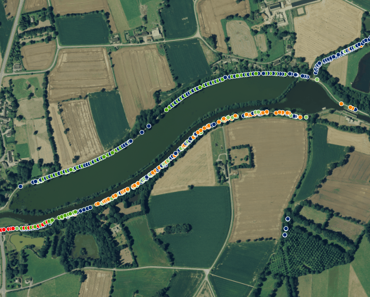
Patrimoine arboré ponctuel des voies navigables appartenant à la Région Bretagne
Caractéristiques des arbres d'alignements présents sur le Domaine Public Fluvial (DPF) de la Région Bretagne comprenant notamment l'espèce, l'évaluation de la hauteur, du diamètre ainsi que l'état sanitaire.
Simple
- Date (Creation)
- 2007-01-02
- Date (Revision)
- 2021-01-01
- Citation identifier
- https://kartenn.region-bretagne.fr/geonetwork/srv/fre/xml.metadata.get?uuid=4cbd28ac-4de2-49ac-b50f-89370fad68ab
- Status
- Completed
- Point of contact
-
Organisation name Individual name Electronic mail address Role Région Bretagne
Service Aménagement, Foncier et Habitat
Point of contact Région Bretagne
Direction des canaux
Custodian
- Theme
-
-
canal
-
arbre
-
patrimoine arboré
-
état sanitaire
-
données ouvertes
-
233500016
-
-
GéoBretagne v 2.0
-
-
patrimoine naturel : bocage
-
-
GEMET - INSPIRE themes, version 1.0 INSPIRE themes
-
-
Habitats et biotopes
-
Resource constraints
- Access constraints
- Other restrictions
- Other constraints
- Pas de restriction d'accès public
- Use limitation
-
Réutilisation libre sous réserve des mentions obligatoires sur tout document de diffusion : "Source : Région Bretagne"
- Use limitation
-
Licence ouverte : https://www.etalab.gouv.fr/licence-ouverte-open-licence
- Use constraints
- License
- Spatial representation type
- Vector
- Denominator
- 1000
- Language
-
fre
- Character set
- UTF8
- Topic category
-
- Biota
))
- Reference system identifier
- RGF93 / Lambert 93 (EPSG:2154)
- Distribution format
-
Name Version ESRI Shapefile
1.0
- OnLine resource
-
Protocol Linkage Name OGC:WMS
https://ows.region-bretagne.fr/geoserver/rb/wms?REQUEST=GetCapabilities&SERVICE=WMS arbre_vn
OGC:WFS
https://ows.region-bretagne.fr/geoserver/rb/wfs?REQUEST=GetCapabilities&SERVICE=WFS arbre_vn
WWW:LINK-1.0-http--link
https://kartenn.region-bretagne.fr/vn Application Kartenn Canaux
- Hierarchy level
- Dataset
Conformance result
- Date (Publication)
- 2013-12-10
- Explanation
-
Non évalué
- Pass
- No
- Statement
-
Inventaire réalisé par l'ONF (Office National des Forets) sur le canal d'Ille et Rance en 2006 et par le bureau d'étude AAPA en 2014 pour la Vilaine, le Blavet, l'Aff et le canal de Nantes à Brest (de Redon à Guerlédan). Toutes ces données ont été collectées via relevé GPS. La base de donnée est mise à jour annuellement par une visite sur le terrain par le responsable du patrimoine arboré et/ou ponctuellement par les agents de terrain.
Metadata
- File identifier
- 4cbd28ac-4de2-49ac-b50f-89370fad68ab XML
- Metadata language
-
fre
- Character set
- UTF8
- Hierarchy level
- Dataset
- Hierarchy level name
-
Jeu de données
- Date stamp
- 2025-05-26T15:54:36
- Metadata standard name
-
ISO 19115:2003/19139
- Metadata standard version
-
1.0
- Metadata author
-
Organisation name Individual name Electronic mail address Role Région Bretagne
Service Aménagement, Foncier et Habitat
Point of contact
Overviews
Spatial extent
Provided by