 Catalogue GeoBretagne
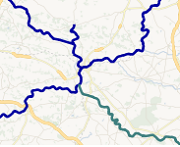
Voies navigables en Bretagne
Cette série de données contient les tronçons de voies navigables en Bretagne. Informations sur le gestionnaire, le propriétaire et le concessionnaire du tronçon.
Simple
- Date (Creation)
- 2011-03-01
- Date (Revision)
- 2021-01-01
- Citation identifier
- https://kartenn.region-bretagne.fr/geonetwork/srv/fre/xml.metadata.get?uuid=7cab44b0-4639-43f2-a824-3eecb7d3bf66
- Status
- Completed
- Point of contact
-
Organisation name Individual name Electronic mail address Role Région Bretagne
Service Aménagement, Foncier et Habitat
Point of contact Région Bretagne
Direction des voies navigables
Custodian
-
GEMET - INSPIRE themes, version 1.0
-
-
Hydrographie
-
233500016
-
-
GEMET
-
-
voie navigable
-
- Theme
-
-
données ouvertes
-
-
external
-
-
mobilité transport : transport maritime et fluvial
-
-
Open Data Région Bretagne
-
-
Culture – Tourisme – Patrimoine – Sports
-
- Access constraints
- Other restrictions
- Other constraints
- Pas de restriction d'accès public
- Use limitation
-
Réutilisation libre sous réserve des mentions obligatoires sur tout document de diffusion : "Source : Région Bretagne"
- Use limitation
-
Licence ouverte : https://www.etalab.gouv.fr/licence-ouverte-open-licence
- Use constraints
- License
- Spatial representation type
- Vector
- Denominator
- 25000
- Language
-
fre
- Character set
- UTF8
- Topic category
-
- Inland waters
- Description
-
Bretagne et Loire Atlantique
))
- Reference system identifier
- EPSG / RGF93 / Lambert-93 (EPSG:2154) / 7.4
- Topology level
- Abstract
- Distribution format
-
Name Version ESRI Shapefile
1.0
- Distributor contact
-
Organisation name Individual name Electronic mail address Role Région Bretagne
Distributor
Digital transfer options
- OnLine resource
-
Protocol Linkage Name OGC:WMS
https://ows.region-bretagne.fr/geoserver/rb/wms?REQUEST=GetCapabilities&SERVICE=WMS voie_navigable
WWW:LINK-1.0-http--link
https://kartenn.region-bretagne.fr/sviewer/?layers=rb:voie_navigable Visualiseur simple
OGC:WFS
https://ows.region-bretagne.fr/geoserver/rb/wfs?REQUEST=GetCapabilities&SERVICE=WFS voie_navigable
- Hierarchy level
- Dataset
Conformance result
- Title
-
INSPIRE Data Specification on Hydrography - Guidelines v 3.0.1
- Date (Publication)
- 2010-05-03
- Explanation
-
Non évalué
- Pass
- No
- Statement
-
Tronçon navigables récupérés sur la BD Carto et corrigé avec l'orthophotographie
Metadata
- File identifier
- 7cab44b0-4639-43f2-a824-3eecb7d3bf66 XML
- Metadata language
-
fre
- Character set
- UTF8
- Hierarchy level
- Dataset
- Date stamp
- 2025-07-11T08:14:47.041439Z
- Metadata standard name
-
ISO 19115
- Metadata standard version
-
1.0
- Metadata author
-
Organisation name Individual name Electronic mail address Role Région Bretagne
Service Aménagement, Foncier et Habitat
Point of contact
)))