Catalogue GeoBretagne
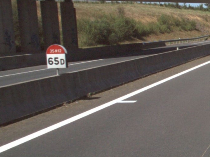
PR (points de repère) sur RN - DIR Ouest
Bornage du réseau routier DIR Ouest, numéros des bornes, longueurs des inter-PR
Simple
- Alternate title
-
PR sur RN
- Date (Revision)
- 2022-11-28T10:00:00
- Edition
-
2021
- Citation identifier
- https://geobretagne.fr/geonetwork/srv/fre/xml_iso19139?uuid=8e5b8e1e-f2f8-4d4a-8496-2c284e03bbb1
- Purpose
-
Permettre la localisation sur un itinéraire routier
- Status
- Completed
- Point of contact
-
Organisation name Individual name Electronic mail address Role DIR Ouest
DIR/SG/PSI/MIG
mig.psi.sg.diro@developpement-durable.gouv.fr
Point of contact
- Maintenance and update frequency
- Annually
- Resource format
-
Name Version Points_de_repères_DIRO.shp
2014
- Place
-
-
Bretagne
-
-
external._none_.gemet
-
-
route à grande circulation
-
DIRO
-
PR
-
Borne
-
Point de repère
-
DIRO
-
diro
-
-
local._none_.geobretagne
-
-
Infrastructures de transport
-
-
GéoBretagne v 2.0
-
-
mobilité transport : transport routier et voirie
-
-
INSPIRE themes
-
-
Réseaux de transport
-
- Theme
-
-
données ouvertes
-
- Use limitation
-
Usage libre sous réserve des mentions obligatoires sur tout document de diffusion : "Source : DIR Ouest"
- Use limitation
-
Licence ouverte : https://www.etalab.gouv.fr/licence-ouverte-open-licence
- Access constraints
- Other restrictions
- Use constraints
- License
- Other constraints
-
Pas de restriction d’accès public
- Spatial representation type
- Vector
- Denominator
- 5000
- Language
-
fre
- Topic category
-
- Transportation
- Description
-
Bretagne Pays de Loire
))
- Supplemental Information
-
Géolocalisation des PR par GPS, mesure des inter-PR sur le terrain.
La dénomination des PR contient un PR Droit et un PR Gauche seul le PR Gauche est identifié par la lettre G.
- Reference system identifier
- EPSG / RGF93 / Lambert-93 (EPSG:2154) / 7.4
- Geometric object type
- Point
Distributor
- Distributor contact
-
Organisation name Individual name Electronic mail address Role DIR Ouest
DIR Ouest
mig.psi.sg.diro@developpement-durable.gouv.fr
Distributor
- Distributor format
-
Name Version ESRI Shapefile
1.0
- OnLine resource
-
Protocol Linkage Name WWW:DOWNLOAD-1.0-http--download
https://geobretagne.fr/geonetwork/srv/api/records/8e5b8e1e-f2f8-4d4a-8496-2c284e03bbb1/attachments/pr.jpg
- OnLine resource
-
Protocol Linkage Name OGC:WMS
https://geobretagne.fr/geoserver/dir_ouest/wms pr_diro
- OnLine resource
-
Protocol Linkage Name OGC:WFS
https://geobretagne.fr/geoserver/dir_ouest/wfs pr_diro
- Hierarchy level
- Dataset
Conformance result
- Date (Publication)
- 2013-12-10T16:51:00
- Explanation
-
Degré de conformité de la ressource par rapport aux spécifications visées d'Inspire: Non Evalué
INSPIRE Data Specification on Transport Networks – Technical Guidelines 3.2
- Pass
- No
- Statement
-
Géolocalisation des PR sur le terrain avec GPS
- Description
-
GPS en X Y
- Denominator
- 5000
- Reference system identifier
- RGF Lambert 93
Metadata
- File identifier
- 8e5b8e1e-f2f8-4d4a-8496-2c284e03bbb1 XML
- Metadata language
-
fre
- Character set
- UTF8
- Hierarchy level
- Dataset
- Hierarchy level name
-
Jeu de données
- Date stamp
- 2024-01-16T14:10:42
- Metadata standard name
-
ISO 19115
- Metadata standard version
-
1.0
- Metadata author
-
Organisation name Individual name Electronic mail address Role DIR Ouest
DIRO/DIR/SG/PSI/MIG
mig.psi.sgmaaps.diro@developpement-durable.gouv.fr
Author
Overviews
Spatial extent
Provided by