Catalogue GeoBretagne
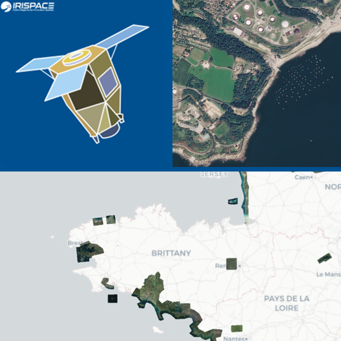
Imagerie spatiale Pléiades ponctuelle ORTHO-SAT®
Les images Pléiades, à 50 cm de résolution spatiale, appelée très haute résolution spatiale (THRS) sont disponibles ponctuellement sur le territoire, au gré des commandes réalisées dans le cadre du dispositif DINAMIS. Ce dispositif de mutualisation permet aux utilisateurs institutionnels de commander gratuitement des images dans la limite d'un quota. Toutes les images acquises sont ensuite référencées dans le catalogue DINAMIS, disponibles gratuitement aux utilisateurs institutionnels en téléchargement et en visualisation via les géoservices de l'IGN. L'IGN assure l'ortho-rectification des images, pour constituer des "orthos satellites".
Simple
- Date (Publication)
- 2022-05-25T00:00:00
- Citation identifier
- https://geobretagne.fr/geonetwork/srv/fre/xml_iso19139?uuid=b3d32cff-ed9f-46ec-afe5-0b71ac5d44cc
- Status
- On going
- Point of contact
-
Organisation name Individual name Electronic mail address Role IRISPACE
Marie Jagaille
Distributor
- Maintenance and update frequency
- Annually
-
GEMET - INSPIRE themes, version 1.0
-
-
Ortho-imagerie
-
-
GEMET - Concepts, version 2.4
-
-
satellite
-
image satellite
-
photographie aérienne
-
satellite d'observation
-
- Theme
-
-
ImageryBaseMapsEarthCover
-
ortho-imagerie
-
référentiel
-
référentiels : imagerie
-
satellitaire
-
copernicus régional
-
données ouvertes
-
- Place
-
-
Bretagne
-
Morbihan
-
Ille et Vilaine
-
Côtes d'armor
-
Finistère
-
- Use limitation
-
Usage libre hors applications commerciales sous réserve des mentions obligatoires de la source : "Contient des informations © Airbus DS XXXX [année d'acquisition], © Production IRD, Irstea, IGN, tous droits réservés"
- Use limitation
-
CC-BY-NC 4.0
- Access constraints
- Other restrictions
- Use constraints
- License
- Other constraints
-
Pas de restriction d’accès public
- Spatial representation type
- Grid
- Denominator
- 5000
- Language
-
fre
- Topic category
-
- Imagery base maps earth cover
))
- Distribution format
-
Name Version GeoTIFF
1.0
JPEG 2000
2.0
- OnLine resource
-
Protocol Linkage Name OGC:WMTS-1.0.0-http-get-capabilities
https://data.geopf.fr/wmts?SERVICE=WMTS&VERSION=1.0.0&REQUEST=GetCapabilities ORTHOIMAGERY.ORTHO-SAT.PLEIADES.2022
OGC:WMTS-1.0.0-http-get-capabilities
https://data.geopf.fr/wmts?SERVICE=WMTS&VERSION=1.0.0&REQUEST=GetCapabilities ORTHOIMAGERY.ORTHO-SAT.PLEIADES.2021
OGC:WMTS-1.0.0-http-get-capabilities
https://data.geopf.fr/wmts?SERVICE=WMTS&VERSION=1.0.0&REQUEST=GetCapabilities ORTHOIMAGERY.ORTHO-SAT.PLEIADES.2020
OGC:WMTS-1.0.0-http-get-capabilities
https://data.geopf.fr/wmts?SERVICE=WMTS&VERSION=1.0.0&REQUEST=GetCapabilities ORTHOIMAGERY.ORTHO-SAT.PLEIADES.2019
OGC:WMTS-1.0.0-http-get-capabilities
https://data.geopf.fr/wmts?SERVICE=WMTS&VERSION=1.0.0&REQUEST=GetCapabilities ORTHOIMAGERY.ORTHO-SAT.PLEIADES.2018
OGC:WMTS-1.0.0-http-get-capabilities
https://data.geopf.fr/wmts?SERVICE=WMTS&VERSION=1.0.0&REQUEST=GetCapabilities ORTHOIMAGERY.ORTHO-SAT.PLEIADES.2017
OGC:WMTS-1.0.0-http-get-capabilities
https://data.geopf.fr/wmts?SERVICE=WMTS&VERSION=1.0.0&REQUEST=GetCapabilities ORTHOIMAGERY.ORTHO-SAT.PLEIADES.2016
OGC:WMTS-1.0.0-http-get-capabilities
https://data.geopf.fr/wmts?SERVICE=WMTS&VERSION=1.0.0&REQUEST=GetCapabilities ORTHOIMAGERY.ORTHO-SAT.PLEIADES.2015
OGC:WMTS-1.0.0-http-get-capabilities
https://data.geopf.fr/wmts?SERVICE=WMTS&VERSION=1.0.0&REQUEST=GetCapabilities ORTHOIMAGERY.ORTHO-SAT.PLEIADES.2014
OGC:WMTS-1.0.0-http-get-capabilities
https://data.geopf.fr/wmts?SERVICE=WMTS&VERSION=1.0.0&REQUEST=GetCapabilities ORTHOIMAGERY.ORTHO-SAT.PLEIADES.2013
WWW:LINK-1.0-http--link
https://cms.geobretagne.fr/teledetection Toutes les ressources et activités du Pôle métier
WWW:LINK-1.0-http--link
https://cms.geobretagne.fr/sites/default/files/documents/fiches_2_comprendre_une_image_satellitaire_1.pdf Lien vers des fiches pdf
WWW:LINK-1.0-http--related
https://dinamis.data-terra.org/ Lien vers la page web et le catalogue du dispositif
- Hierarchy level
- Series
Conformance result
- Date (Publication)
- 2010-10-23
- Explanation
-
Non Evalué
- Pass
- No
- Statement
-
Les images Pléiades sont acquises à bord du satellite à 70 cm de résolution (au nadir) pour le mode spectral panchromatique (noir et blanc) et à 2,8 m de résolution (au nadir) pour le mode multispectral (couleur). Elles sont ensuite ré-échantillonnées au sol à 50 cm pour rendre les produits robustes aux différents traitements informatiques qui seront réalisés ensuite. La résolution des produits Pléiades distribués par Airbus DS est de 50 cm en mode panchromatique et de 2 m en mode multispectral. L'IGN assure l'ortho-rectification des images, pour constituer des "orthos satellites"; et leur distribution en géoservices.
Metadata
- File identifier
- b3d32cff-ed9f-46ec-afe5-0b71ac5d44cc XML
- Metadata language
-
fre
- Character set
- UTF8
- Hierarchy level
- Series
- Hierarchy level name
-
Collection de données
- Date stamp
- 2025-05-05T14:03:09.579962Z
- Metadata standard name
-
ISO 19115
- Metadata author
-
Organisation name Individual name Electronic mail address Role IRISPACE
Marie Jagaille
Point of contact
Overviews
Spatial extent
Provided by